Crop marks
Ground monuments that are no longer recognizable above ground, or only with difficulty, become recognizable in the aerial photograph through various features at different times of the year and/or in certain climatic contexts[1].
The following characteristics are generally distinguished:
- Soil discolorations
- Crop marks
- Shadow characteristics
- Snow characteristics
- Humidity characteristics
- Water characteristics
- Thermal characteristics
Soil discolorations
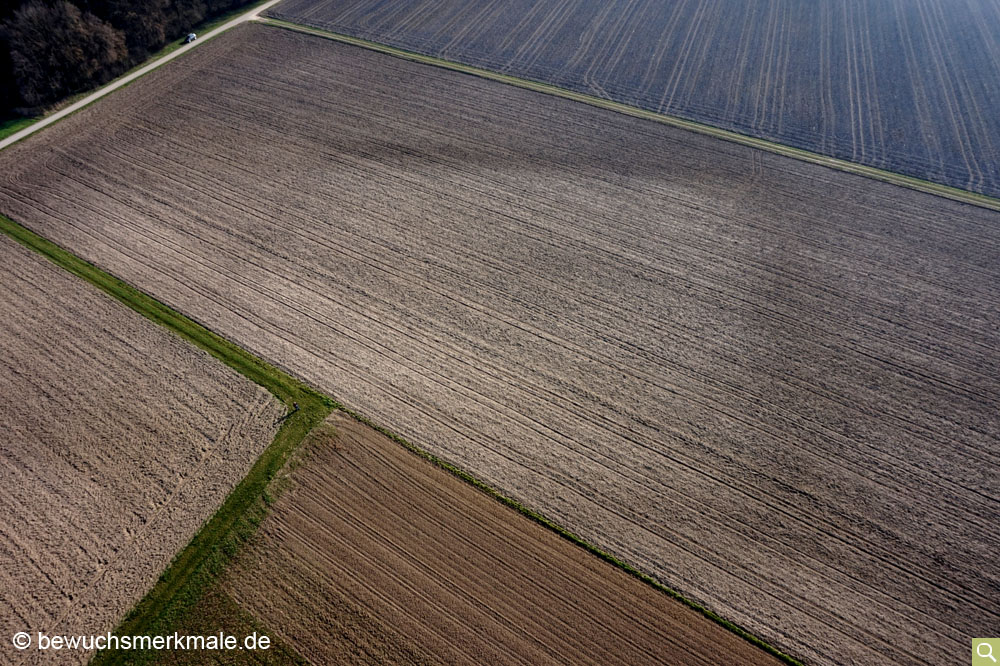
Many ground monuments can usually be identified as soil discolorations in freshly plowed fields in the fall or spring. Pits, wells or ditches were filled after their abandonment by erosion or human hand. This filling then often shows a different color than the still unchanged, surrounding soil. But also paths and former ramparts can be seen in the arable soil, if the now flattened fills were made of foreign material (stone packs, material taken from deeper layers, etc.).
Crop marks
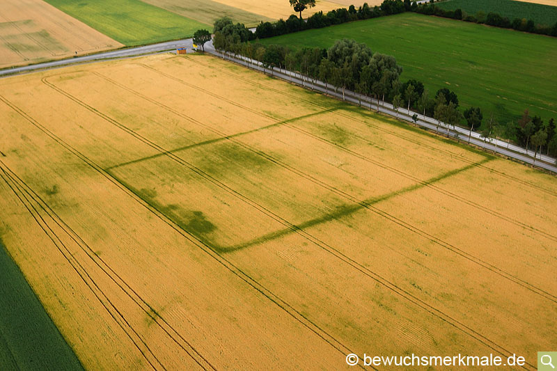
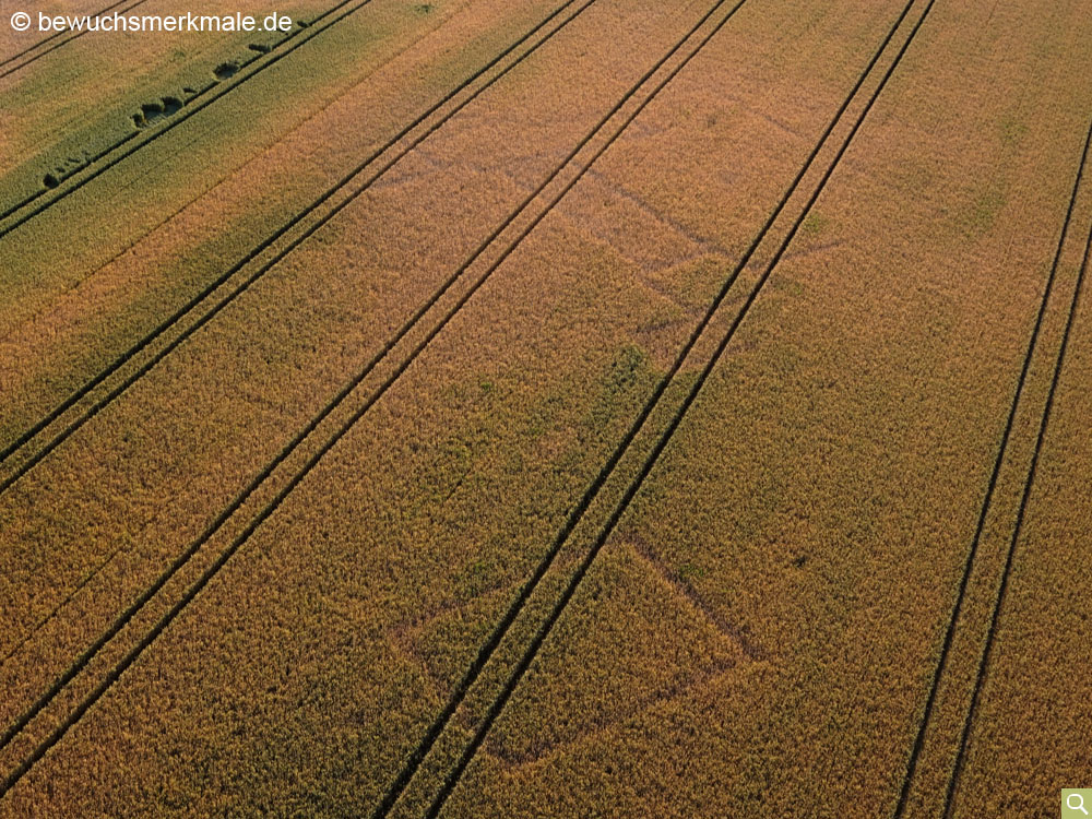
Today's technically highly equipped agricultural industry creates large field areas on which crops are planted very homogeneously. Plant density (e.g. for corn) has also been further increased in recent years. Under optimal conditions, plants grow at the same rate and mature at the same time. However, if there are different soil conditions within an area, this has a varying effect on length growth and fruit maturity, especially during periods of extreme weather. Cereals in particular then show such soil differences through different plant sizes or coloration. But also in corn, rapeseed or soybean can be discovered growth characteristics [2] [3].
A distinction is made between positive and negative crop marks.If plants grow faster and/or taller than their surrounding plants due to better nutrition, this is called a positive crop marks. This also includes
plants that remain green longer than their surrounding, earlier maturing neighboring plants due to better water supply. Such differences are often easily seen in
aerial photographs.

On the other hand, negative crop marks result from reduced growth, paler leaf coloration or earlier maturation due to less favorable soil conditions.
These can be caused, for example, by wall remains still present underground, floors or old paths.

Shadow characteristics
Smaller elevations (such as flattened burial mounds) or slight depressions (e.g., caused by an almost completely filled-in ditch) are often still visible in the aerial photograph when the sun is low. The cast shadow created by the difference in elevation, which becomes particularly prominent when the sun is low, exposes such ground irregularities. Positive and negative crop marks become even more visible through shadow characteristics.
Snow characteristics
Ground monuments can also become visible from the air during the winter months through the formation of frost or snow features. Snow features come in two types. In the first type, the first snow often melts on heat-retaining soil structures (such as walls) while remaining on surrounding soils. It is just the opposite in a dew period: The snow remains longer on the places where the cold is stored longer in the soil, while the neighboring soils are already free of snow.
Another type of snow feature is created by snow drifts. When the wind is stronger from one direction, the snow is carried away and redeposits in places where there is no wind. While in the places where the snow has been blown away, the darker soil becomes visible again, the more windless places (such as depressions or the windward side of burial mounds) are highlighted by a snow accumulation.
Actually to the shadow characteristics belongs the effect that with continuous snow cover and the particularly low-standing sun in the winter half-year elevations and depressions become clearly visible due to the long cast shadows.
Humidity characteristics
Moisture or moisture characteristics form in soil structures with different water storage capacities. As soon as the soil dries again after a rain, the soils with the better
water storage remain darker in colour for longer, while the neighbouring soils are already drier and thus lighter in colour.

Water characteristics
Another type of feature occurs during floods or inundations. While much of the ground disappears under the even surface of the water, slight elevations (e.g. of burial mounds) still peek out from the water surface.
Thermal characteristics
Thermal imaging cameras can be used to capture another type of feature, so-called thermal characteristics. If thermal differences arise between two surfaces, these can be made visible with a thermal imaging camera. Such thermal features usually only exist for a short time and can be explained by different causes.
- Different soil conditions: If the soil conditions of two adjacent areas differ, this is usually due to differences in the density, grain size and water permeability of the soil. This is associated with different physical behavior. If these soils are subject to large short-term temperature increases, the soils heat up at different rates. The situation is similar in the case of strong cooling, as one of the soils may then retain the heat longer than its neighboring surface. Typical representatives of such thermal differences are snow characteristics, where the snow acts as an indicator of the temperature differences. A different water content or a different water permeability can also cause a temperature difference between two surfaces. Humidity characteristics are then also recognizable as thermal characteristics.
- Heating of plants: When plants are exposed to heat and prolonged drought, they react with drought stress. A side effect of this is that the plants heat up due to the lack of water. This means, for example, that wall lines in the ground become visible in the thermal image, which may not be recognizable in a normal image.

[1] A detailed overview with many examples can be found, among others, at Braasch 2005 page 12-37 and Song/Leidorf/Heller 2019 Kap. 2.4
[2] Krause 2014
[3] Krause 2013
